Sachsenbrücke: Why Two Bridges Are Planned for the Hafentor Quarter
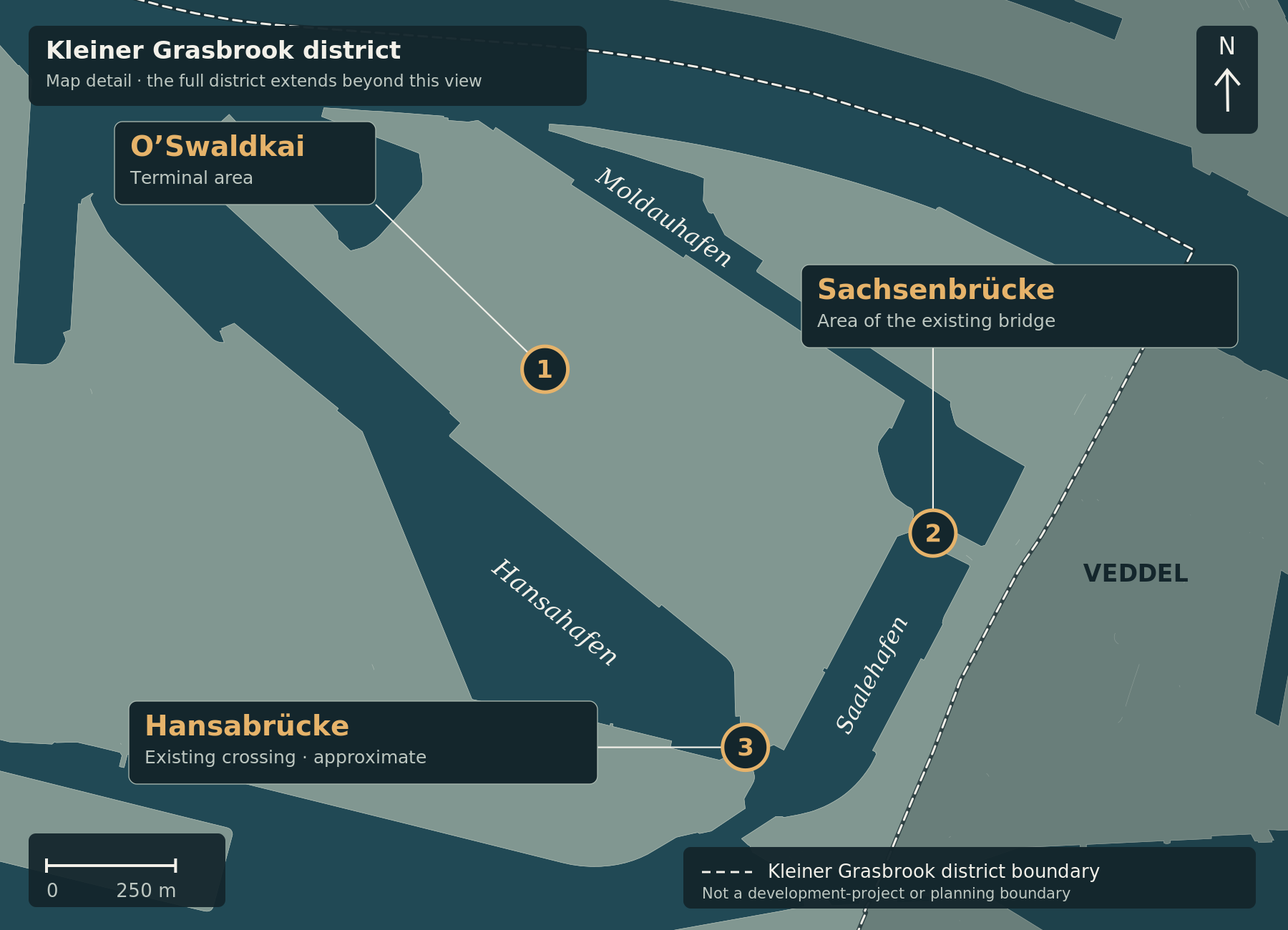
Marker 2 identifies the area of the existing Sachsenbrücke. O’Swaldkai (1) and Hansabrücke (3, approximate location) provide neighbouring reference points. The planned replacement bridges are not shown. The light-coloured lines connect markers to labels; they are not roads.
Sachsenbrücke links Veddel with the area of the future Hafentor Quarter. The winning replacement design proposes two separate structures: a traffic bridge and an additional promenade bridge. HafenCity Hamburg GmbH published its description on 5 May 2026. This article explains that established planning proposal; it does not report a newly decided competition. Project description
A traffic crossing and a waterside connection
The southern bridge is intended to carry motor traffic and cyclists. The description specifies an approximately seven-metre-wide carriageway and separate accessible cycle and footways. Alongside it, a slender steel bridge is proposed for the pedestrian promenade, connecting waterfront paths around Moldauhafen and Saalehafen. schlaich bergermann partner with gmp produced the winning design. How the two structures are arranged
Competition organiser D&K drost consult confirms the winning team and the brief to combine access to the future Hafentor Quarter with public space. Completion of the design competition does not mean that the crossing itself has been built. Competition record
How it relates to port traffic
The new O’Swaldkai terminal access road is intended to run alongside the port railway and connect to Veddeler Damm via Hansabrücke. According to the developer, this change frees land for commercial development in the Hafentor Quarter. The access road and the Sachsenbrücke replacement are connected projects, but they are distinct construction schemes. Terminal access project summary
2028 means a possible construction start
Under the published timetable, removal of the existing bridge is intended to begin from mid-2027. Construction of the replacement may start in spring 2028. This is not an announcement that the new bridges will open in 2028. The sources examined do not provide a confirmed completion date or detailed temporary traffic arrangements. Developer’s timetable
Sources checked on 25 September 2026. The map marks the existing crossing; it does not invent an alignment or planning boundary for the proposed structures.
The orientation map and its explanation have been updated. The article’s subject-matter source review date remains unchanged.
Image credit: Cartography: ChatGPT for kleiner-grasbrook.net, 4 October 2026. Land and water: Free and Hanseatic City of Hamburg, State Agency for Geoinformation and Surveying (LGV), ALKIS simplified, adapted; stored basemap grasbrook-alkis-2026-09-22-v1, retrieved on 22 September 2026 according to the original manifest. Administrative boundary: LGV, ALKIS administrative boundaries Hamburg, district 117; from the GeoJSON archive uploaded by Thomas on 4 October 2026, layer app_stadtteile_EPSG_25832.json. Both datasets: Data Licence Germany – Attribution 2.0. Upload and ZIP timestamps are not survey or effective dates. This is not a record of current construction progress.
Additional points in the detail maps: O’Swaldkai, Sachsenbrücke, museum and PEKING from documented OpenStreetMap records via Mapcarta, OpenStreetMap contributors, ODbL. S Veddel from Wikidata Q7917951, CC0. Hansabrücke is an approximate editorial area anchor retained from V0.4, not a surveyed bridge centre. Point locations were not newly surveyed in this revision; inherited sources are documented in sources/places.json.
ALKIS vereinfacht · ALKIS Verwaltungsgrenzen Hamburg · Datenlizenz Deutschland / Data Licence Germany 2.0 · OpenStreetMap · Wikidata Q7917951