New access road to O’Swaldkai: Reorganising port traffic and Hafentorquartier
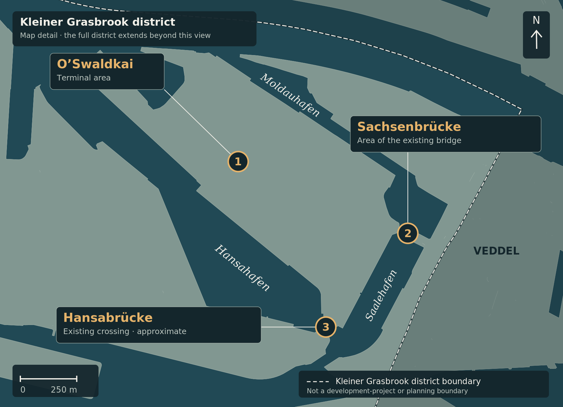
The map marks the O’Swaldkai terminal area (1), the area of the existing Sachsenbrücke (2) and the approximate location of Hansabrücke (3). The light-coloured lines connect markers to their labels; they do not represent roads. Neither the new terminal access road nor a boundary of the planned Hafentorquartier is shown.
South of Moldauhafen, existing port operations and the development of the new Grasbrook district meet directly. The O’Swaldkai terminal will remain in active port use, while the neighbouring Hafentorquartier is planned as a new commercial district. A road project already under construction is intended to reorganise traffic between these areas. Urban development concept
A new route for terminal traffic
HafenCity Hamburg GmbH has been building a new access road to the O’Swaldkai terminal since October 2024. It is intended to serve both the port terminal and Edeka’s fruit distribution facility. According to the published project information, the road will run alongside the port railway and connect to Veddeler Damm via Hansabrücke. Construction activities
The current construction period is stated as lasting until the end of 2027 or the beginning of 2028. The works include site clearance, unexploded-ordnance investigations, earthworks, utility works and road construction. The client is HafenCity Hamburg GmbH in coordination with Hamburg Port Authority. Construction activities
Making room for Hafentorquartier
The project is not simply about providing a different terminal entrance. According to the project developer, the new traffic routing will free up land in Hafentorquartier for future commercial development. Construction activities
The district lies south of Moldauhafen and west of Saalehafen. It is planned primarily for research and development, digital businesses, services and urban production. Housing is not planned within Hafentorquartier because the area remains part of the port zone. The neighbouring O’Swaldkai terminal, meanwhile, is to continue operating as a conventional cargo terminal. Urban development concept
Construction is already affecting local traffic
The current road situation shows that construction is well under way. Hamburg Port Authority lists Dessauer Straße from the Hansabrücke direction as fully closed, currently from 1 February 2025 until 31 August 2027. HPA traffic information
Traffic travelling from Veddeler Damm towards Dessauer Straße, Asiastraße and Hansahafen is being diverted via Sachsenbrücke. According to HPA, the Am Saalehafen/Sachsenbrücke junction is being adapted so that vehicles can turn left onto Sachsenbrücke. HPA traffic information
The new terminal access road therefore serves two purposes at once: it reorganises traffic for an operating port terminal and creates the spatial conditions for further development of Hafentorquartier.
Sources checked on 4 October 2026. Construction has been under way since October 2024; this article does not report a new construction start.
Image credit: Cartography: ChatGPT for kleiner-grasbrook.net, 4 October 2026. Land and water: Free and Hanseatic City of Hamburg, State Agency for Geoinformation and Surveying (LGV), ALKIS simplified, adapted; stored basemap grasbrook-alkis-2026-09-22-v1, retrieved on 22 September 2026 according to the original manifest. Administrative boundary: LGV, ALKIS administrative boundaries Hamburg, district 117; from the GeoJSON archive uploaded by Thomas on 4 October 2026, layer app_stadtteile_EPSG_25832.json. Both datasets: Data Licence Germany – Attribution 2.0. Upload and ZIP timestamps are not survey or effective dates. This is not a record of current construction progress.
Additional points in the detail maps: O’Swaldkai, Sachsenbrücke, museum and PEKING from documented OpenStreetMap records via Mapcarta, OpenStreetMap contributors, ODbL. S Veddel from Wikidata Q7917951, CC0. Hansabrücke is an approximate editorial area anchor retained from V0.4, not a surveyed bridge centre. Point locations were not newly surveyed in this revision; inherited sources are documented in sources/places.json.
ALKIS vereinfacht · ALKIS Verwaltungsgrenzen Hamburg · Datenlizenz Deutschland / Data Licence Germany 2.0 · OpenStreetMap · Wikidata Q7917951