Neue Elbbrücke bridge works: revised traffic arrangements on Amsinckstraße
The Neue Elbbrücke entered the final announced phase of its current repair programme on Thursday, 15 October 2026. At the same time, new time slots for the temporary traffic arrangements on Amsinckstraße took effect following a burst water main. The changes concern different parts of the wider road corridor but matter together for journeys between Veddel, central Hamburg, HafenCity and the area around Kleiner Grasbrook. Hamburg’s bridge update, 13 October and Amsinckstraße update, 15 October.
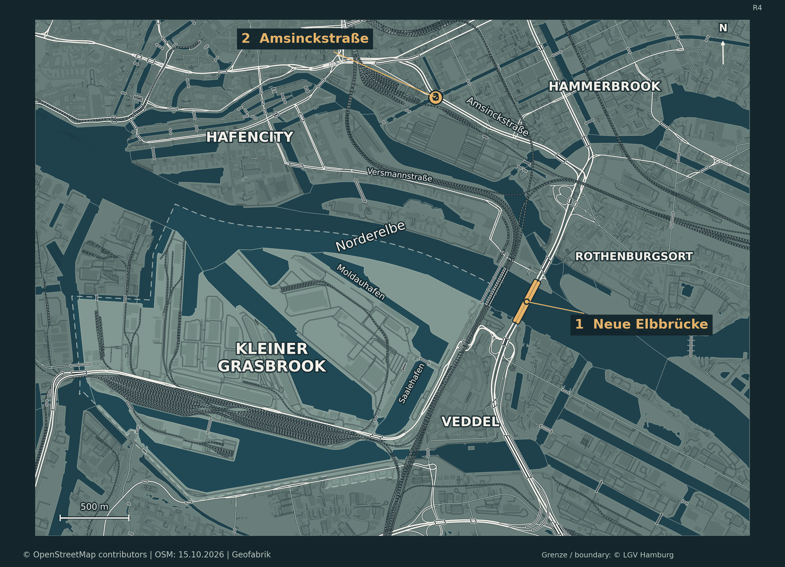
The Neue Elbbrücke is marked 1 and the Amsinckstraße location is marked 2. The dashed line is the official administrative boundary of Kleiner Grasbrook, not a worksite boundary.
What is being repaired on the bridge
Hamburg’s State Agency for Roads, Bridges and Waterways (LSBG) is now repairing the central bus corridor (Kommunaltrasse), along with concrete structures, bearings and expansion joints connecting sections of the bridge with the road. The transport ministry says the work is necessary to maintain safety and the bridge’s continued use. The city-bound side was repaired in 2025; work on the outbound side has been under way since March 2026. The switch to the new phase was scheduled overnight on 14–15 October. Source: Hamburg transport ministry, 13 October.
For the Neue Elbbrücke, the city currently reports four traffic lanes towards the city centre and three outbound. Turns into HafenCity are to remain possible from both directions. The green phase for motor vehicles at the Versmannstraße/Baakenwerder Straße junction is to be extended. Drivers may nevertheless encounter delays. Bridge announcement, 13 October.
The transport authority has not yet announced when this phase will finish. Current LSBG project information.
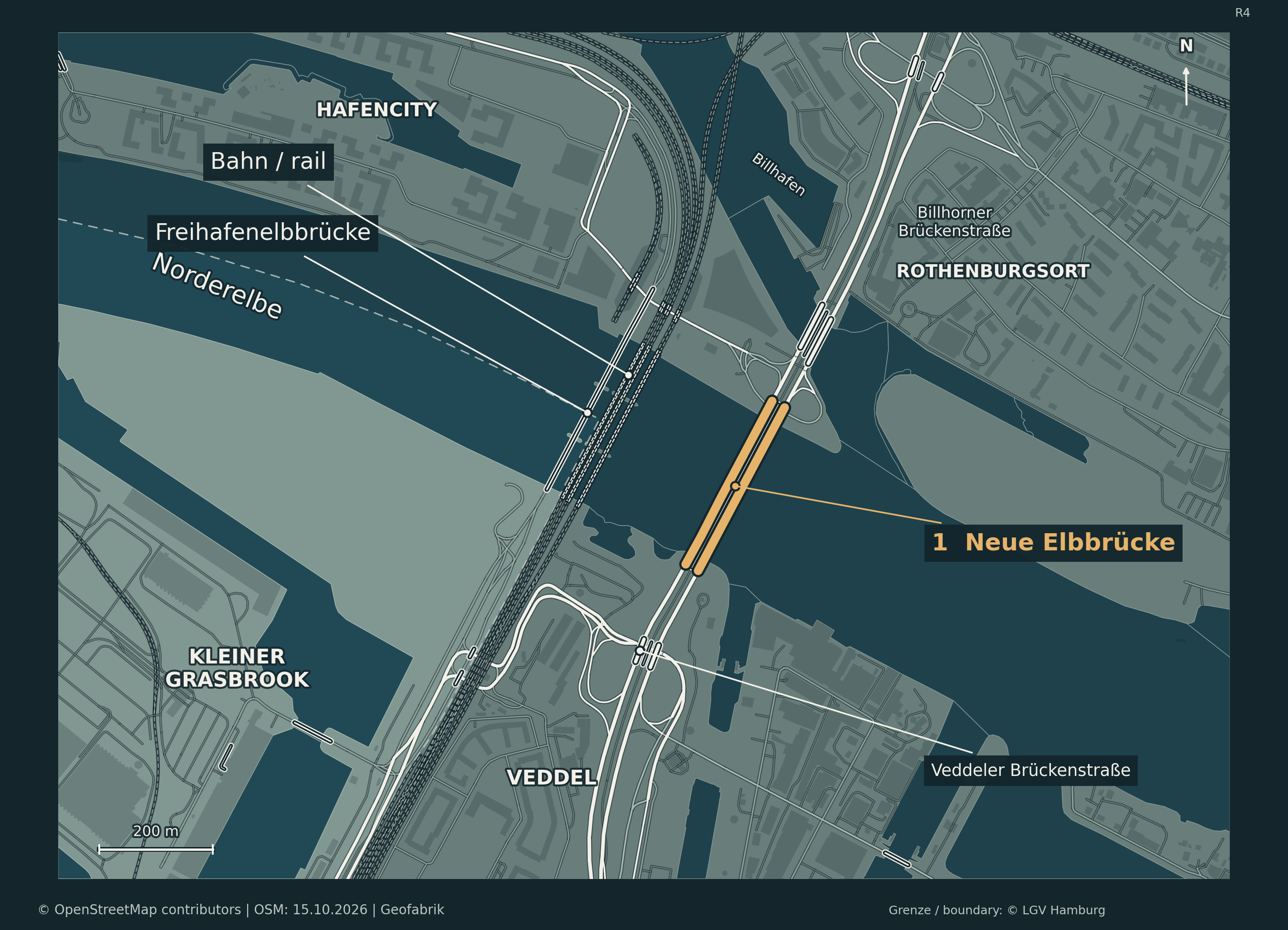
From west to east, the map shows Freihafenelbbrücke, the railway crossings and the Neue Elbbrücke highlighted in gold. Track symbols distinguish railways from the solid road lines. Bridge widths are cartographic symbols, not measured lanes.
Amsinckstraße: The new daily timetable
Further north, the temporary lane arrangement on Amsinckstraße has been modified because of the consequences of a burst water main. Following an initial assessment of traffic, the ministry moved its daily switch-over times one hour later. The timetable announced on 15 October applies seven days a week for now:
- 06:00–12:00: two lanes for inbound motor traffic, plus a separate inbound bus lane. Outbound vehicles can use Nordkanalbrücke and Recha-Lübke-Damm.
- 12:00–06:00 the following day: the regular arrangement provides three outbound traffic lanes; the inbound bus lane remains open.
Short disruptions may occur while lanes are reconfigured, particularly between 05:00 and 06:00 and 11:00 and 12:00. Outbound traffic is also narrowed to a single lane for around 150 metres between Recha-Lübke-Damm and Lippeltstraße. The authorities are monitoring the impact and may adjust the arrangement again. Source: Hamburg transport ministry, 15 October.
A crucial distinction: The four inbound lanes refer to the Neue Elbbrücke. The two inbound lanes during morning hours refer to a different stretch of Amsinckstraße. The figures are not interchangeable and do not contradict each other.
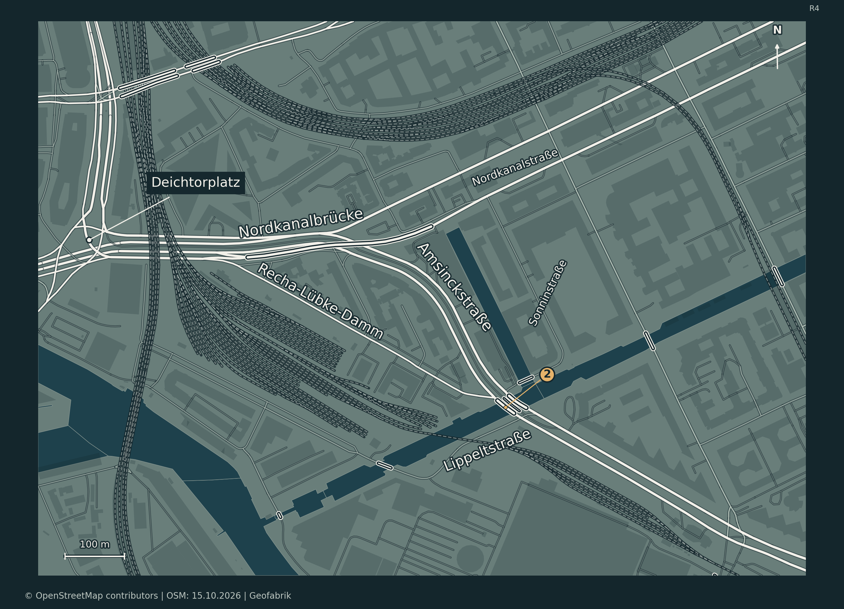
Deichtorplatz, Nordkanalbrücke, Recha-Lübke-Damm and Lippeltstraße are shown in context. Marker 2 identifies the area of the bottleneck. Its short leader ends on Amsinckstraße; the map does not draw an exact barrier or worksite boundary.
Why this matters near Grasbrook
The B4/B75 river-crossing corridor links the Elbe islands and port area with central Hamburg. The LSBG is working on several different bridge structures along this route. Anyone travelling from Veddel or around Kleiner Grasbrook to the city centre or HafenCity therefore needs to consider both the bridge arrangement and the time-dependent restrictions on Amsinckstraße. The city advises drivers to avoid the area where possible or use public transport. LSBG project overview and official traffic advice.
The works are on the existing Neue Elbbrücke. The additional relief bridge planned to its west is a separate project and is intended to open in 2028. Hamburg Senate announcement, 22 September.
Information checked on 16 October 2026.
Cartography: ChatGPT for kleiner-grasbrook.net, 16 October 2026. Roads, tracks, water and buildings: © OpenStreetMap contributors, ODbL 1.0; Geofabrik Hamburg extract, data timestamp in the README: 15 October 2026, 20:21 UTC. Source: hamburg-261015-free.gpkg.zip uploaded by Thomas. Adaptations: cropping, projection to EPSG:25832, selection, Nachtatlas colours and labelling. Administrative boundary: Free and Hanseatic City of Hamburg, State Agency for Geoinformation and Surveying (LGV), ALKIS administrative boundaries, district 117; unchanged coordinates from the GeoJSON file stored in the project. Data Licence Germany – Attribution 2.0. The earlier upload on 4 October 2026 is not a survey date.
OpenStreetMap · ODbL 1.0 · Geofabrik Hamburg · LGV license · OSM data extract used (GeoPackage, ODbL 1.0)